Kanchenjunga Base Camp Trek
| Trip code | |
| Package name | Kanchenjunga Base Camp Trek |
| Duration | 23 |
| Max. elevation | 5150 m |
| Level | Moderate |
| Transportation | All ground transportation as per itinerary |
| Accomodation | Hotel in Kathmandu, lodges during the trek |
| Starts at | Kathmandu |
| Ends at | Kathmandu |
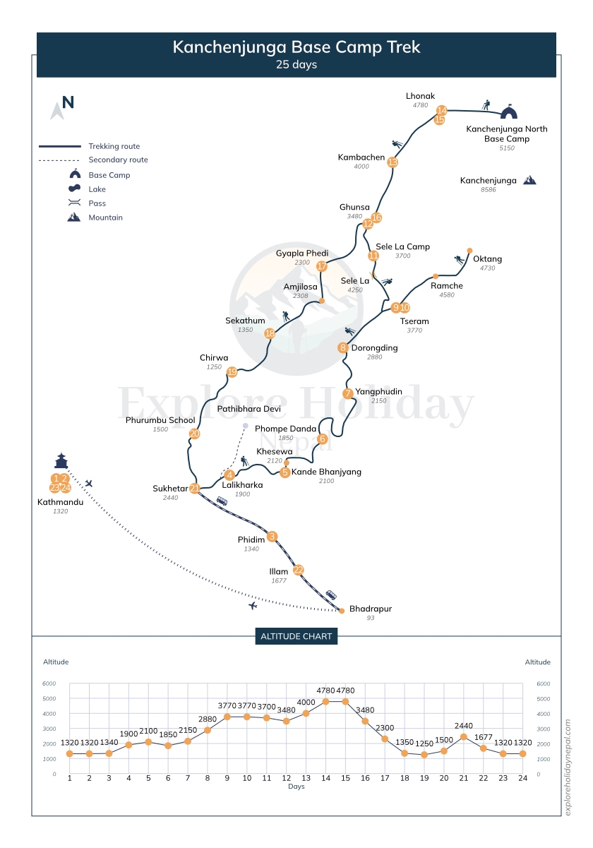
| Trip route | Kathmandu - Bhadrapur - Sukhetar - Kanda Bhanjyang - Phompe Danda - Yangphudin - Doronding - Tseram - Kanchenjunga South BC - Sele La Pass - Ghunsa - Khambachen - Lhonak - Kanchenjunga North BC - Ghunsa - Gyapla Phedi - Sekathum - Chirwa - Phurumbhu School - Sukhetar - Illam Bazaar - Bhadrapur - Kathmandu |
| Cost | USD 2,725 per person |
Highlights
- Witness breathtaking views of the Kanchenjunga massif, including the main summit and its neighboring peaks like Yalung Kang, Kangbachen, and Jannu.
- Trek through remote and unspoiled landscapes, experiencing the raw beauty of alpine meadows, dense forests, and high mountain passes.
- Encounter diverse ethnic communities such as the Limbu, Rai, Sherpa, and Tibetan people, each with their own unique traditions, languages, and lifestyles.
- Explore both the North and South Base Camps of Kanchenjunga, providing an opportunity to get up close to the colossal mountain and its surrounding glaciers.
- Challenge yourself with high-altitude passes like Sele La and Sinion La, offering stunning panoramic views of the surrounding peaks and valleys.
Overview

Kanchenjunga Trek: The Ultimate Guide to Nepal's Hidden Giant
So you want to trek to the third highest mountain in the world? Good choice. But here's the thing—while everyone's posting selfies at Everest Base Camp, Kanchenjunga sits quietly in far eastern Nepal, practically ignored. Which is exactly what makes it special.
Mount Kanchenjunga stands at 8,586 meters (28,169 feet), and unlike its more famous neighbors, this mountain hasn't been completely overrun by commercial tourism. The trek to its base camps remains genuinely remote, culturally rich, and physically demanding in all the right ways.
But let's get one thing straight from the start—this isn't a beginner's trek. Not even close.
Why Kanchenjunga Trek Stays Off Most People's Radar
Here's something interesting. You'd think the third highest mountain on Earth would attract massive crowds, right? Wrong. Most trekkers in Nepal never make it to Kanchenjunga. Why?
First, location. It's way out east, almost touching the Sikkim and Tibet borders. Getting there requires either a long, bone-rattling jeep ride or a flight to Taplejung followed by days of walking just to reach the actual trek starting point. Not exactly convenient.
Second, time commitment. You're looking at 18-20 days minimum for the full experience. That's nearly three weeks. Most people just don't have that kind of vacation time available.
Third, difficulty level. This trek demands previous high-altitude experience, good fitness, and mental toughness. It's not your introduction to Himalayan trekking—it's more like your graduation ceremony.
But honestly? These "barriers" have created something beautiful. The Kanchenjunga Trek has avoided the overcrowding and commercialization that's changed other popular routes. What you get instead is authentic mountain culture, genuine solitude, and an experience that feels more like exploration than tourism.
The Mountain Itself: Five Treasures of Snow
The name "Kanchenjunga" comes from Tibetan and means "The Five Treasures of Snow." Look at the mountain from certain angles and you'll see why—it's actually a massive massif with five distinct peaks, each one impressive enough to be famous on its own.
The four main summits create an incredible skyline:
- Main Summit (8,586m) - The big daddy, third highest in the world
- Kanchenjunga West (Yalung Kang) (8,505m) - Just slightly shorter
- Kanchenjunga Central (8,482m) - Still over 8,000 meters
- Kanchenjunga South (8,494m) - Rounding out the giants
And here's something cool—the mountain is considered sacred by locals. Climbers who summit actually stop a few feet below the true peak out of respect for local beliefs. Try finding that kind of reverence on Everest's crowded summit.
From the trek, you'll see all these peaks from multiple angles. The north face from Pangpema Base Camp. The south face from Oktang. Different perspectives on the same massive mountain that'll make you feel wonderfully small.
The Landscape: From Jungle to Glacier in One Trek
One of the most mind-blowing aspects of the Kanchenjunga Trek is the sheer variety of landscapes you'll walk through. It's not just "mountain scenery"—it's everything.
You start low. Really low. Around 1,500-2,000 meters in subtropical lowlands where humidity makes you sweat through your clothes before lunch. Dense forests tower overhead. The vegetation is so thick you can barely see the sky. You hear birds, insects, rushing water. It feels more like jungle trekking than mountain climbing.
Then you start climbing. And the world changes.
Rhododendron forests dominate the mid-elevations. If you trek in spring (March-May), these forests explode in color—massive rhododendron trees covered in red, pink, and white blooms. It's honestly spectacular. Even if you don't care about plants, the visual impact is undeniable.
Higher still, you enter alpine meadows. The trees thin out, replaced by hardy grasses and wildflowers. The air gets noticeably thinner. Your breathing deepens. Stone cairns and prayer flags start appearing—signs you're entering the high Himalayas.
By the time you reach the base camp areas around 5,000+ meters, you're in a completely different universe. Barren rock. Glacial moraines. Ice fields stretching toward peaks that seem close enough to touch but would take days to reach. The only sounds are wind, your breathing, and occasionally prayer flags snapping.
This elevation journey—from humid jungle to frozen alpine zones—happens gradually over days of walking. You earn every meter. And your body has time to adapt, which is crucial at these altitudes.
The Trail: Two Base Camps, Twice the Reward
Unlike most treks that visit one destination, the Kanchenjunga Trek actually takes you to two different base camps. You get perspectives from both the north and south sides of the massif, which completely changes how you see the mountain.
North Base Camp (Pangpema) - 5,143 meters
The northern route follows the stunning Ghunsa Valley, following the Ghunsa Khola river upstream. This valley is gorgeous—one of those places that makes you stop frequently, not because you're tired (though you are), but because the scenery demands attention.
Ghunsa village itself is substantial. Maybe 30-40 houses, several lodges, a monastery, and locals who've been hosting trekkers long enough to perfect their hospitality without losing authenticity. You'll spend a rest day here for acclimatization—use it wisely. Take short hikes, explore the monastery, talk to locals, let your body adjust.
From Ghunsa, the trail continues to Khambachen (4,050m) and then Lhonak (4,780m). Each village gets progressively smaller, more remote, more rugged. By Lhonak, you're truly in the high mountains. The landscape is stark. Beautiful in a harsh way.
The final push to Pangpema Base Camp (5,143m) is relatively short but intense. And then you arrive, and the north face of Kanchenjunga absolutely dominates your vision. It's so close, so massive, that your brain struggles with the scale. You'll also see Wedge Peak, Tent Peak, and several other giants that would be famous anywhere else but are overshadowed here.
Sunrise at Pangpema is magical. The first light hitting those white peaks, slowly turning them pink, then orange, then brilliant white. People cry. I'm not kidding—the emotional impact of being there, after days of hard trekking, watching those mountains come alive... it's powerful.
South Base Camp (Oktang/Yalung) - 4,730 meters
The southern approach via Oktang (also called Yalung Base Camp) offers completely different perspectives and feels even more remote somehow.
The Yalung Valley is less visited than Ghunsa, which means even fewer trekkers. Villages like Tseram (3,870m) and Ramche (4,580m) are tiny—maybe 3-4 lodges total. The people are incredibly welcoming, partly because they see so few foreigners.
The trail to Oktang winds through moraines and rocky terrain. It's not technical, but it's tiring—lots of ups and downs over uneven ground at altitude. But then you reach the base camp, and the south face of Kanchenjunga spreads before you like a massive wall of ice and rock.
From this angle, you can clearly see all five peaks that give the mountain its name. The perspective is broader, more panoramic than the north face. It's less dramatic maybe, but more comprehensive. You're seeing the whole mountain spread out in its full glory.
What's amazing about visiting both base camps is how different the same mountain looks. It's like meeting two different giants that happen to be connected. Together, north and south perspectives give you a complete understanding of why Kanchenjunga is considered one of Earth's most beautiful mountains.
The High Passes: Where Your Legs Remember You're Human
Let's talk about the challenging bits. The Kanchenjunga Trek includes crossing high mountain passes that'll test everything—your fitness, your determination, your ability to function on limited oxygen.
Sele La Pass (4,290m) and Sinion La Pass (4,660m) are the main ones connecting the north and south valleys. Neither requires technical climbing skills or ropes, but both are serious undertakings.
Sele La has a reputation among guides and porters. The approach is relentlessly uphill through forest that provides zero views to distract you from the burning in your thighs. You just climb. And climb. And when you think you're nearly there, you climb more. At altitude, this means lots of breaks—walk 15-20 steps, stop and breathe, repeat for hours.
But reaching the top? That makes every step worth it. Prayer flags stretch in colorful lines, snapping in the wind. Mountain views open up in all directions. You've crossed from one valley to another, using your own two feet at over 4,000 meters. That's worth celebrating.
Sinion La is higher and can be snow-covered depending on season. The final approach to the pass requires careful footing over loose rocks. The descent on the other side is steep—your knees will remind you that going down is often harder than going up.
Trekking poles aren't optional for these passes. They're essential equipment that'll save your joints and prevent falls on steep, rocky sections.
Wildlife: More Than Just Mountains
One surprise about the Kanchenjunga Trek is the incredible biodiversity. The Kanchenjunga Conservation Area protects some of the richest ecosystems in the eastern Himalayas.
Red pandas live in these forests. Yes, actually. They're shy, rare, and spotting one requires incredible luck, but they're out there in the rhododendron forests. More commonly, you'll see:
- Himalayan tahr (a goat-antelope) on rocky slopes
- Blue sheep grazing on distant ridges
- Danphe (Himalayan monal)—Nepal's national bird with iridescent plumage
- Various pheasant species
- Countless smaller birds
Higher up, Himalayan griffons soar on thermal currents, their massive wingspans silhouetted against blue skies. The region is home to snow leopards, though seeing one is lottery-level luck. Just knowing they're out there, watching from rocky hideouts, adds wildness to the experience.
The flora is equally impressive. Spring brings explosions of wildflowers—orchids, primulas, blue poppies. Even the mosses and lichens create intricate patterns on rocks and trees. If you're into photography or just appreciate natural beauty, bring extra memory cards.
Cultural Immersion: Three Distinct Communities
The Kanchenjunga Trek isn't just scenery. The cultural experience rivals the natural beauty.
Limbu People (Lower Elevations)
The lower regions are Limbu territory. They're one of Nepal's indigenous groups with their own language (which sounds nothing like Nepali), traditions, and agricultural practices. Walk through a Limbu village and you'll see:
- Terraced fields carved into impossible slopes
- Traditional houses with thatched or tin roofs
- Women in colorful traditional dress
- Men working fields or carrying enormous loads
The Limbus are warm and curious about foreigners. They'll often invite trekkers to try tongba (fermented millet beer served warm) or raksi (strong local alcohol). Accepting is good manners. Just pace yourself—that stuff is stronger than it tastes.
Rai Communities
Rai people also inhabit parts of the trek route. Like the Limbus, they have distinct cultural practices and their own language. Traditional Rai dances during festivals are spectacular—lots of rhythmic movement, colorful costumes, and community participation.
Sherpa and Tibetan Buddhist Communities (Higher Elevations)
Higher up, particularly around Ghunsa and surrounding areas, you enter Sherpa and Tibetan Buddhist territory. The cultural shift is immediately visible:
- Prayer flags everywhere—strung between trees, across rivers, on ridge tops
- Mani walls (long stone walls carved with Buddhist mantras)
- Chortens (Buddhist stupas) marking sacred spots
- Monasteries with spinning prayer wheels
The spiritual atmosphere is palpable. Monks in maroon robes. Elderly villagers circumambulating monuments while spinning prayer wheels. The sound of horns and chanting drifting from monasteries.
Visit Ghunsa Monastery if you can time it with prayer sessions. The monks chanting together, horns echoing, incense filling the air—it's a deeply moving experience even if you're not Buddhist.
Real Village Life
What makes the cultural experience authentic is that these aren't tourist attractions. These are real communities where life continues with or without trekkers. Kids play in alleyways. Women work fields. Men repair stone walls. Grandparents tell stories while grandchildren listen.
If you're lucky enough to be trekking during local festivals, you'll witness traditional celebrations that have been performed for generations. These aren't staged—you just happen to be there when the community gathers. The locals are usually happy to have visitors observe and sometimes even participate.
Cascading Waterfalls and Alpine Lakes
The trail constantly surprises you with water features that deserve mention.
Waterfalls are everywhere, especially in the lower and middle elevations. Some are massive—hundreds of meters of falling water that you hear long before you see. Others are small but perfectly positioned, creating photo opportunities where rainbows form in the mist.
Alpine lakes dot the higher regions. These aren't huge lakes, but they're pristine—crystal clear water reflecting surrounding peaks. Some are sacred to locals, marked by prayer flags and small offerings. The silence around these lakes is profound. Just wind, water, and mountains.
Best Time for Kanchenjunga Trek
Timing your trek matters enormously. This remote region experiences extreme weather variations.
Spring (March to May) - Prime Time
Spring is peak season for good reason. The famous rhododendron forests bloom spectacularly—hillsides covered in red, pink, and white flowers. It's absolutely gorgeous.
Weather stabilizes after winter. March can still be cold and occasionally snowy at high passes, but by April and May, conditions are ideal. Clear skies are common, offering excellent mountain views.
Temperatures are manageable—warm in lower valleys (15-20°C during day), cold but not brutal at high camps. You'll need a good sleeping bag, but you won't freeze.
The downside? This is peak season, meaning more trekkers. Though "crowded" on the Kanchenjunga Trek means you might see 10-15 other groups total rather than complete solitude. It's still far less busy than Annapurna Circuit Trek or Everest Base Camp Trek .
Autumn (September to November) - Also Excellent
After monsoon clears in September, autumn brings the year's clearest skies. The air has been washed clean by months of rain, creating visibility that makes distant peaks seem impossibly close.
October is probably the single best month if you can only choose one. Perfect temperatures, stable weather, crystal-clear mountain views. November gets colder but remains manageable with proper gear.
Culturally, autumn coincides with festival season in Nepal—Dashain and Tihar. You're more likely to witness celebrations, which adds another dimension to the trek.
Winter (December to February) - Hardcore Only
Winter trekking is possible but seriously challenging. Heavy snowfall can close passes. Temperatures drop to -20°C or colder at high camps. Most lodges in upper regions close as residents migrate to lower elevations.
Only attempt winter if you have:
- Extensive cold-weather trekking experience
- Proper gear (4-season sleeping bag, down suit, etc.)
- Flexible schedule (weather delays are likely)
- High tolerance for discomfort
The reward? Total solitude, pristine snow-covered landscapes, and bragging rights.
Monsoon (June to August) - Generally Avoid
Monsoon makes this trek miserable. Heavy rain turns trails muddy and potentially dangerous. Leeches infest lower forests (they're everywhere—on leaves, waiting to drop on you). Rivers swell. Landslide risk increases. Mountain views hide behind clouds.
Some hardcore trekkers go during monsoon for extreme solitude and lower costs. But for most people, the negatives far outweigh benefits.
Physical Difficulty: The Honest Truth
I'm not going to sugarcoat this—the Kanchenjunga Trek is hard. Really hard.
Physical demands: 6-8 hours of trekking daily for 18-20 consecutive days. Not easy hours on flat trails. Steep climbs, rocky descents, river crossings, uneven terrain. Your body will hurt. Blisters despite good boots. Sore muscles. Aching joints.
Altitude: Multiple nights above 3,000 meters, reaching above 5,000 meters at base camps. Altitude sickness is a real risk. Headaches, nausea, fatigue, sleep difficulty—these symptoms can hit anyone regardless of fitness. Proper acclimatization is crucial.
Remoteness: Help is far away. This isn't Everest Base Camp Trek where helicopters reach you in hours. Evacuation from Kanchenjunga is complicated and expensive. This demands taking safety seriously—proper preparation, insurance, listening to your body.
Mental challenge: Three weeks of sustained effort tests you psychologically. Tough days where you question your decisions. Where your body screams and your mind says "enough." Pushing through requires mental toughness.
Who should attempt this?
You should have:
- Previous multi-day trekking experience (2-3 treks of 7+ days ideally)
- Experience at altitude (at least one trek to 4,000+ meters)
- Good general fitness (comfortable walking 6-8 hours with backpack)
- Mental resilience for discomfort
- Flexible schedule (weather can force delays)
If your biggest outdoor challenge is day hikes, this isn't your next step. Build up gradually. Try Annapurna Base Camp Trek or Langtang Valley Trek first. Learn how your body handles altitude and sustained effort. Then come to Kanchenjunga.
What You'll Eat
Food on the Kanchenjunga Trek is simple, filling, and designed to power you through long days.
Lower villages offer variety: dal bhat (rice and lentils—the trekker's staple), momos (dumplings), fried rice, noodle soups, Tibetan bread, pancakes, eggs. Food is fresh because supplies reach these villages regularly.
Higher up, menus shrink. Dal bhat becomes the mainstay—unlimited servings of rice, lentil soup, vegetables, sometimes a bit of meat. "Dal bhat power, 24 hour" is a common trekking joke because it genuinely fuels you effectively.
Other high-altitude options: potato dishes, noodle soups, Tibetan bread with yak cheese. Don't expect gourmet meals. Expect warm, filling food that keeps you moving.
Bring supplemental snacks from Kathmandu: energy bars, chocolate, nuts, dried fruit. When altitude kills your appetite, familiar comfort food helps. Just pack out all wrappers—leave no trace.
Accommodation Reality Check
Lodges range from decent to extremely basic depending on elevation.
Lower villages (Taplejung, Mitlung, Chiruwa): Standard trekking lodges. Private or semi-private rooms. Foam mattresses. Communal dining areas. Shared bathrooms with (sometimes) hot water for extra fee. Comfortable enough.
Mid-altitude villages (Ghunsa, Khambachen): Similar facilities, though hot water becomes less reliable. Electricity from solar panels with limited hours.
Upper camps (Lhonak, Ramche, near base camps): Very basic. Small rooms, thin mattresses, basic blankets (bring warm sleeping bag), shared pit toilets, no showers (wet wipes become your friend), minimal electricity, communal dining heated by yak-dung stoves.
Is it uncomfortable? Compared to home, yes. But you have shelter, hot meals, and company. That's luxury at 4,500+ meters.
Important note: Lodges are family-run, not commercial hotels. Owners are opening their homes to you. Treat them and property with respect. Be patient with service (they're cooking for everyone over wood fires). Be generous with tips at the end.
Safety and Health
The trek's remoteness demands serious attention to safety.
Altitude sickness prevention:
- Follow acclimatization schedule religiously
- Ascend slowly (don't skip rest days)
- Stay hydrated (3-4 liters daily minimum)
- Recognize symptoms early (headache, nausea, dizziness)
- Descend immediately if symptoms worsen
Medical preparedness:
- Comprehensive first aid kit
- Altitude medication (discuss Diamox with doctor beforehand)
- Extra prescription medications
- Basic first aid knowledge
Communication:
- Phone signal nonexistent in most areas
- Satellite phones recommended for emergencies
- Your guide has communication devices
Insurance is ESSENTIAL: Must cover:
- Helicopter evacuation from high altitude (6,000m minimum)
- Medical treatment for altitude illness
- Emergency repatriation
- Trip cancellation/interruption
Evacuation can cost $10,000+ without insurance. Don't skip this.
Packing Essentials
Clothing:
- Base layers (2-3 sets) - wool or synthetic, no cotton
- Insulation - fleece, down jacket (quality matters)
- Outer shell - waterproof/windproof jacket and pants
- Trekking pants (2), shirts (3) - quick-dry
- Warm hat, sun hat, gloves (light and heavy pairs)
- Wool/synthetic socks (5-6 pairs)
Footwear:
- Broken-in waterproof trekking boots
- Camp shoes or sandals
- Gaiters
Gear:
- Sleeping bag rated -15°C minimum
- Trekking poles (essential)
- Headlamp with extra batteries
- Water bottles (3 liters capacity)
- Sunglasses with UV protection
- Sunscreen SPF 50+ and lip balm
Medical:
- First aid kit (bandages, antiseptic, blister treatment)
- Altitude medication
- Pain relievers, anti-diarrhea meds
- Water purification
- Personal prescriptions (bring extras)
Why This Trek Changes People
I've talked to many Kanchenjunga trekkers. Almost everyone says it changed something for them.
Part is the physical challenge. Pushing beyond what you thought possible creates confidence that transfers to regular life. Work problems feel smaller after climbing to 5,000 meters.
Part is cultural immersion. Time in communities operating so differently from modern life expands perspective. You realize how many ways exist to live well.
Part is the beauty. Standing among Earth's highest peaks under impossibly clear skies does something to your soul. Humbling and elevating simultaneously.
But mostly, it's the combination. Physical challenge plus cultural depth plus natural beauty plus genuine remoteness equals transformation.
The people you meet—villagers inviting you into homes, guides sharing mountain knowledge, fellow trekkers pushing through same challenges—become part of your story.
Final Thoughts
The Kanchenjunga Trek isn't for everyone. It's challenging, uncomfortable at times, and requires real commitment.
But for those willing to push beyond standard tourist experiences, it delivers something increasingly rare—authentic adventure in genuinely remote territory. The combination of massive peaks, diverse landscapes, authentic cultures, and real solitude creates an experience popular treks cannot match.
You'll work hard for three weeks. Your body will hurt. You'll sleep in basic lodges and go days without showers. Weather might force changes.
And you'll return home with memories lasting a lifetime. You'll have explored the third highest mountain on Earth through terrain few people see. You'll have tested your limits and discovered strength you didn't know existed.
If you've got the fitness, experience, time, and adventurous spirit, this trek deserves consideration. Just make sure you're properly prepared, choose a reliable trekking company, and approach the journey with respect these mountains demand.
Do that, and Kanchenjunga will give you an adventure you'll measure all others against.
Top Blogs About Trekking in the Kanchenjunga Region:
Uncover the best blogs about trekking in the Kanchenjunga region, featuring expert advice, detailed itineraries, personal experiences, and essential tips for adventurers looking to explore the Himalayas.
Altitude Sickness on Nepal Treks: Symptoms, Treatment, and When to Descend (Complete Guide)
Ultimate Kanchenjunga Circuit Trek Guide
Amazing Facts About the Kanchenjunga Circuit Trek
Kanchenjunga North vs. South Base Camp: Which is Better?
Trekking Kanchenjunga Circuit: Routes, Planning & Survival Tips for Adventurers
Amazing Top Facts of Mount Kanchenjunga
Nepal Trekking Permits: Costs, Types, and How to Get Them
Nepal Trekking: What’s the Best Time to Go?
Budget Trekking in Nepal: Tips, Trails, and Tricks
Exploring Nepal’s Wildlife and Nature
Trekking Through Nepal: A Journey into the Himalayas
Top 10 Mountain Peaks in Nepal
Monastery Life in Nepal: Finding Peace in the Heart of the Himalayas
Altitude Sickness on Nepal Treks: Symptoms, Treatment, and When to Descend (Complete Guide)
Dal Bhat Power 24 Hour: The Science and Soul Behind Nepal's Mountain Fuel
Solo Female Trekking in Nepal: A Complete Safety and Empowerment Guide for 2026
Complete Fitness Training Guide for Nepal Trekking 2026: From Couch to Base Camp in 12 Weeks
Trip Preparation
- Thermal underwear (top and bottom)
- Moisture-wicking t-shirts (long-sleeved)
- Moisture-wicking underwear
- Fleece jacket or pullover
- Insulated down or synthetic jacket
- Waterproof, windproof jacket (Gore-Tex or similar)
- Waterproof, windproof pants (Gore-Tex or similar)
- Warm beanie or hat
- Sun hat or cap
- Neck gaiter or scarf
- Trekking pants (convertible preferred)
- Waterproof trousers
- Lightweight gloves (inner)
- Insulated gloves or mittens (outer)
- Hiking boots (broken in and waterproof)
- Comfortable camp shoes (e.g., sneakers or sandals)
- Trekking backpack (30-40 liters) with waterproof cover
- Sleeping bag (rated for cold temperatures)
- Sleeping pad or mattress (insulated)
- Adjustable trekking poles
- Insulated water bottles or hydration bladder (2 liters capacity)
- Travel-sized toiletries
- Biodegradable soap
- Quick-dry towel
- Medications for altitude sickness, pain relief, and common ailments
- Sun protection cream, wet wipes, and hand sanitizer
- Camera and batteries
- Notebook and pen
- Earplugs (for sleeping in lodges)
- Portable solar charger
- Headlamp, power bank, and extra batteries
Trip Itinerary
Day 1 : Arrival in Kathmandu and transfer to the hotel.
You'll land at Tribhuvan International Airport where our team will be waiting to take you to your hotel in Thamel. First impressions of Kathmandu? Busy, loud, and totally exciting.
Once you've checked in, just relax. Seriously. Long flights are exhausting, and jet lag hits differently for everyone. If you crash for a few hours, that's completely fine. If you're feeling good though, Thamel's right outside—narrow streets packed with gear shops, restaurants, and the kind of organized chaos that somehow just works here.
Need to grab any last-minute supplies? Now's the time. Exchange some money too (you'll need cash in the mountains). Hungry? There are dozens of restaurants serving everything from dal bhat to pizza. Your call.
Later today or tomorrow morning, we'll sit down together to go over the trek details, check your gear, and answer whatever questions you've got. Think of it as your final prep before things get real.
Get a good night's sleep. Tomorrow we start moving toward Kanchenjunga.
Day 2 : Fly Kathmandu to Bhadrapur, drive to Phidim 1,340 m.
Early morning flight to Bhadrapur in far eastern Nepal. The flight's about 45 minutes, and if you get a window seat on the right side, you'll catch views of the Himalayas on clear days. Pretty incredible way to start the day.
Bhadrapur's a small town near the Indian border—hot, humid, and completely different from Kathmandu. From here, it's a 5-6 hour drive to Phidim through winding hill roads. The drive can be long and bumpy (Nepal's roads aren't exactly smooth), but the scenery makes up for it. You'll pass through terraced farmlands, small villages, and lush green hills that give you a taste of what's coming.
Phidim sits at 1,340 meters and feels worlds away from the capital. It's a quiet hill town where the trek officially begins tomorrow. Tonight you'll stay in a basic lodge—nothing fancy, but clean and comfortable enough.
Use the evening to stretch your legs, walk around town a bit, and get your body ready. The real trekking starts tomorrow, so eat well and get good rest. You're officially in the eastern hills now.
Day 3 : Drive to Sukhetar 2,440 m, trek to Lali Kharka 1,900 m.
Another jeep ride today—about 4 hours from Phidim to Sukhetar at 2,440 meters. The roads get rougher as you climb higher, so brace yourself for some serious bumps. But you're heading into proper mountain territory now, and the views start getting more interesting.
Sukhetar's basically the official gateway to the Kanchenjunga region. This is where your actual trekking begins. From here, you'll trek downhill (yeah, you read that right—down from 2,440m to 1,900m) to Lali Kharka. Takes about 3 hours through forests and small settlements.
The descent might feel a bit weird since you just drove uphill, but that's how this trek works—lots of ups and downs. Your knees will get a workout, so take it slow and use your trekking poles if you've got them.
Lali Kharka's a small place with basic teahouses. Nothing fancy, but the people are friendly and the dal bhat's hot. You're officially trekking now. Tomorrow the real climbing starts.
Day 4 : Trek to Kande Bhanjyang 2,100 m - 06 hrs.
Today's a proper trekking day—around 6 hours to Kande Bhanjyang at 2,100 meters. The trail goes up and down through forests, small villages, and terraced farmlands. You'll cross a few streams and probably work up a good sweat on the uphill sections.
This is where you start noticing the cultural mix of the region. You'll pass through Limbu and Rai villages where life moves at mountain pace—people working their fields, kids playing outside, locals curious about where you're headed. Take your time through these settlements. The hospitality here is genuine, and a quick "namaste" goes a long way.
The forest sections are beautiful, especially if there's decent weather. Rhododendrons, oak trees, and if you're lucky, some wildlife sightings. Keep your eyes open.
Kande Bhanjyang's a small ridge-top settlement with a few teahouses. The views start opening up from here if the clouds cooperate. Your legs will be tired after 6 hours, so stretch well tonight. Tomorrow's another full day of trekking.
Day 5 : Trek to Phompe Danda 1,850 m - 06 hrs.
Another 6-hour day, heading down to Phompe Danda at 1,850 meters. Notice you're losing altitude again? That's just how this trek works—constant ups and downs before you really start climbing high later on.
The trail today winds through some really nice forest sections. It's quieter here, fewer villages, more just you and the trees. Good day for some headspace if you need it. The downhill sections give your lungs a break but your knees will feel it, so don't rush.
You might spot some interesting birds along the way—this area's pretty good for that if you're into wildlife. Even if you're not, the forest is peaceful. Just nice walking.
Phompe Danda's small, maybe 2-3 teahouses total. Basic setup as usual—simple room, shared bathroom, communal dining area. But after 6 hours of walking, it'll feel just fine. The lodge owners here are used to trekkers and know what you need—hot food and a place to crash.
Rest up. You've got more kilometers ahead tomorrow.
Day 6 : Trek to Yangphudin 2,150 m at Sherpa Gaon - 06 hrs.
Six hours to Yangphudin today, which locals also call Sherpa Gaon. You're climbing back up to 2,150 meters, so your lungs will remind you they're working at altitude again.
The trail passes through several Sherpa villages—actual lived-in communities, not tourist stops. You'll see stone houses, prayer flags, and locals going about their daily routines. Kids might follow you for a bit, curious about trekkers. Wave, say hello, maybe share a smile. That's often the best part of these days.
The scenery's getting better as you gain altitude. On clear stretches, you'll start catching glimpses of bigger peaks in the distance. Not the full Kanchenjunga view yet, but enough to remind you what you're heading toward.
Yangphudin has a few lodges run by Sherpa families. The cultural vibe shifts here—you'll notice more Tibetan Buddhist influences, prayer wheels, maybe hear some different languages being spoken. It feels more mountain-like, less lowland Nepal.
Six-hour days are becoming your normal now. Your body's probably adjusting to the rhythm. Eat well tonight, hydrate, rest those legs. Still more trekking ahead before we reach the base camps.
Day 7 : Trek to Doronding 2,880 m via Lashe Tham-La - 06 hrs.
Today you're crossing Lashe Tham-La pass and climbing to 2,880 meters at Doronding. Six hours of trekking with a decent amount of uphill, so pace yourself.
The pass isn't crazy high, but it's your first proper climb since starting the trek. You'll feel it in your legs and lungs. Take breaks when you need them—there's no prize for rushing. The top's marked with prayer flags doing their thing in the wind, which is always a nice sight after a climb.
From the pass, you get some really good mountain views if the weather's playing nice. This is where things start feeling more alpine, less jungle-y. The air's thinner up here too, so don't be surprised if you're breathing harder than usual.
Doronding's tiny—basically a few stone houses and a couple of teahouses. It's remote and quiet, which is exactly what you want at this point. The lodge setup is basic but the food's hot and there are beds. That's winning.
You're almost at 3,000 meters now. Your body's adjusting, but drink plenty of water and don't skip dinner even if altitude kills your appetite. Tomorrow keeps climbing.
Day 8 : Trek to Tseram 3,770 m - 05 hrs.
Big jump in altitude today—from 2,880m to 3,770m. That's almost 900 meters gained in about 5 hours of trekking. You'll definitely feel this one.
The trail climbs steadily through changing landscapes. Lower sections still have some tree cover, but as you gain altitude, the vegetation thins out. By the time you reach Tseram, you're properly in alpine territory—less forest, more open meadows, and mountains feeling closer.
Tseram sits in a beautiful valley surrounded by high peaks. It's a small settlement with maybe 3-4 basic lodges. The place gets cold at night (you're at 3,770 meters now), so make sure you've got your warm layers ready.
This is where altitude starts becoming more real. Some people feel it here—maybe a headache, maybe trouble sleeping, maybe just feeling more tired than usual. That's normal. Drink tons of water, skip alcohol, and don't push through serious symptoms. Tell your guide if something feels off.
The good news? Tomorrow's a rest day. Your body needs time to adjust to this altitude before climbing higher. Use it wisely—short acclimatization hike, lots of rest, plenty of fluids.
Day 9 : At Tseram for a hike to Oktang near Kanchenjunga South BC.
Today's your acclimatization day, but you're not just sitting around. The plan is to hike up to Oktang (Yalung Base Camp) at 4,730 meters and then return to sleep at Tseram. Classic "climb high, sleep low" strategy that helps your body adjust.
It's about 3-4 hours up to the base camp from Tseram. The trail's rocky and gets steeper as you go, so take your time. At this altitude, your breathing gets heavier and you'll need more breaks. That's completely normal.
When you reach Oktang, the south face of Kanchenjunga hits you. It's massive—like a wall of ice and rock that doesn't seem real. On clear days, you can see all five peaks that give the mountain its name. It's the kind of view that makes every tough step worth it.
You're at 4,730 meters here, so don't stay too long. Enjoy the moment, take your photos, soak it in. Then head back down to Tseram to sleep at the lower altitude. Your body will thank you for not sleeping this high yet.
After descending, rest up at the lodge. Eat well, hydrate, and congratulate yourself—you just reached Kanchenjunga South Base Camp. That's a real achievement. Tomorrow you start trekking toward the north side.
Day 10 : Cross Sele-La Pass 4,250 m and camp at 3,700 m - 08 hrs.
Long day today—about 8 hours total. You're crossing Sele La Pass at 4,250 meters, which is the highest point you've hit so far on this trek. Then it's a big descent to camp at 3,700 meters.
The climb to Sele La is tough. You're gaining 500 meters from Tseram, and at this altitude, every uphill step feels harder. The trail goes through forest initially, then opens up as you get higher. No views to distract you for most of the climb—just put one foot in front of the other and keep breathing.
When you finally reach the pass, prayer flags mark the top and the relief is real. Take a break, catch your breath, enjoy the moment. You've earned it.
Then comes the descent. And it's long. Your knees are going to feel this—dropping 550 meters over several hours is hard on the joints. Trekking poles are your best friend here. Go slow on the steep sections.
Camp tonight is basic—probably just tents or a very simple shelter. You're in remote territory now. But after 8 hours of trekking, you'll just be glad to stop moving. Eat, rest, sleep. Tomorrow continues the journey north.
Day 11 : Trek to Ghunsa 3,480 m - 04 hrs.
Easier day today—just 4 hours of mostly downhill trekking to Ghunsa at 3,480 meters. After yesterday's 8-hour slog, your legs will appreciate the shorter distance.
Ghunsa's the biggest village you'll see in this part of the trek. Maybe 30-40 houses, a monastery, several lodges, and actual people living their normal mountain lives. It's a proper Sherpa settlement with strong Tibetan Buddhist vibes—prayer flags everywhere, mani walls, spinning prayer wheels.
You'll notice the cultural shift immediately. Stone houses with flat roofs, locals speaking Sherpa and Tibetan dialects, yaks wandering around. It feels different from the lower villages you passed through earlier.
Take some time to walk around if you've got energy. Visit the monastery if it's open. Chat with locals. Buy some snacks or supplies from the small shops—this is your last chance before heading higher toward the north base camp.
The lodges here are decent by mountain standards. You might even get a hot shower (for a fee). Take advantage of it. Tomorrow's a rest day for acclimatization, but tonight just enjoy being in a real village again after that remote camp.
Day 12 : Trek to Khambachen 4,000 m - 06 hrs.
Six hours of trekking today, climbing from 3,480m to 4,000m. You're crossing the 4,000-meter line, which is when altitude really starts making itself known. Expect to breathe harder and move slower.
The trail follows the valley upward, mostly alongside the river. It's a steady climb—not brutal, but relentless. At this elevation, even "easy" sections require effort and frequent breaks.
The scenery's different up here. Trees thin out, the valley widens, and mountains feel closer. Keep your eyes open—you might spot Himalayan tahr on the slopes or maybe some high-altitude birds. The landscape has that sparse, rocky beauty that only exists above 4,000 meters.
Khambachen's small—just 3-4 basic lodges. Rooms are cold, mattresses thin, food simple. This is what mountain lodges actually look like when you get this high. But you'll have a roof, hot dal bhat, and company.
Nights here are seriously cold. Double-check your sleeping bag situation before bed. Layer up. Tomorrow pushes even higher to Lhonak, so hydrate well tonight and get decent rest. Your body's adjusting, but it needs help.
Day 13 : Trek to Lhonak 4,780 m - 06 hrs.
Another 6 hours of climbing today, gaining almost 800 meters to reach Lhonak at 4,780m. This is proper high altitude now. You'll feel it in every breath.
The trail gets rockier and more barren as you climb. Vegetation basically disappears. It's just rock, ice, and the occasional hardy plant clinging to life. The landscape feels harsh but amazing in its own way—raw mountain territory where not much survives.
You're walking on moraines in sections, which means loose rocks and uneven footing. Watch your step. The altitude makes you tired faster, so don't be surprised if you need breaks every 10-15 minutes. That's completely normal at nearly 5,000 meters.
Lhonak is barely a settlement—maybe 2 lodges, super basic. You're at the edge of civilization here. Tomorrow you'll push to Pangpema (North Base Camp) from here, so this is your last stop before the big day.
The altitude hits different at 4,780m. Headaches are common. Sleep might be rough. Some people feel nauseous. Tell your guide if anything feels seriously wrong. Otherwise, just hydrate constantly, eat even if you're not hungry, and try to rest. Base camp's tomorrow.
Day 14 : At Lhonak hike to Pang Pema 5,150 m / 16,896 feet around Kanchenjunga North Base Camp - 07 hours both ways.
This is what you came for. Seven hours round trip to Pangpema at 5,143 meters—the viewpoint for Kanchenjunga North Base Camp. Then back down to sleep at Lhonak.
The hike up takes about 3-4 hours. It's not technically difficult, just high and tiring. You're above 5,000 meters, so your body's running on way less oxygen than normal. Take it slow. Breathe deep. Stop whenever you need to.
The trail follows the glacier moraine—rocky, uneven, sometimes icy patches. Watch your footing. The landscape's completely barren up here. No plants, no animals, just rock and ice and sky.
And then you reach Pangpema. The north face of Kanchenjunga rises right in front of you—this massive wall of ice and rock that's almost too big to comprehend. It's the third highest mountain on Earth, and from here, it feels like you could reach out and touch it. On clear days, the view includes Wedge Peak, Tent Peak, and a bunch of other giants stretching across the horizon.
People get emotional here. After two weeks of trekking, dealing with altitude, pushing through tough days—standing at base camp makes it all click. Take your time. Sit. Look. Process it.
Then head back down to Lhonak to sleep. Don't try staying up here—your body needs lower altitude for the night. The descent takes 2-3 hours. You'll sleep better at 4,780m than you would at 5,143m, trust me.
Day 15 : Trek to Ghunsa 3,480 m - 08 hours.
Long downhill day—8 hours from Lhonak back to Ghunsa. You're dropping over 1,300 meters in one go, which is a lot of descent. Your knees are going to remember this day.
Going downhill feels easier on your lungs since you're dropping altitude, but it's harder on your legs and joints. Trekking poles earn their keep today. Take it slow on the steep sections and don't try to rush just because it's downhill.
You're retracing the same trail you climbed a couple days ago, but it looks different going down. Things you barely noticed on the way up—side valleys, rock formations, distant peaks—stand out more when you're not gasping for air.
The vegetation gradually comes back as you lose altitude. By the time you reach Ghunsa, trees and greenery feel almost weird after days in the barren high country.
Ghunsa will feel like a luxury resort compared to where you've been sleeping. Real lodges, maybe a hot shower, decent food, more oxygen in the air. Your body will appreciate being back at 3,480 meters instead of nearly 5,000.
Rest well tonight. You're heading lower tomorrow, and while the trek isn't over, the hardest high-altitude sections are behind you now.
Day 16 : Trek to Gyapla Phedi 2,300 m - 07 hours.
Seven hours of trekking today, dropping from 3,480m down to 2,300m. That's over 1,100 meters of descent, so yeah, your knees will know you've been walking downhill all day.
The trail goes back through the valley, losing altitude steadily. What felt like hard climbs on the way up now become long descents that test your legs differently. It's not difficult breathing-wise—you're getting more oxygen as you drop—but it's physically tiring in its own way.
The landscape shifts back as you descend. Trees get bigger and denser. The air feels thicker, almost humid compared to the thin, dry air you've been breathing for days. Birds and insects start appearing again. It's wild how much changes in just 1,000 meters of elevation.
Gyapla Phedi is small and basic—a few lodges at the base of tomorrow's pass. Nothing special, but it's got what you need. The lower altitude means you'll probably sleep better tonight than you have in a week.
Your body's transitioning back to lower elevations, which is easier than going up but still takes adjustment. Drink water, stretch those legs out, eat well. Tomorrow you're crossing another pass before the long trek out.
Day 17 : Trek to Sekathum / Japantar 1,350 m - 07 hrs.
Another 7-hour day, but this time you're dropping way down to 1,660 meters. That's getting back into the warm zone where you started this trek weeks ago.
The morning starts with climbing up and over a pass, then it's mostly downhill from there. Your legs are probably pretty tired by now—this is day 18 of walking, after all. The descent is long and can feel endless when you're ready to be done.
The landscape changes dramatically today. You go from alpine terrain back into thick forest. The temperature climbs. You might actually start sweating in a way you haven't since the early trek days. The humidity comes back. It feels almost tropical compared to where you've been.
Sekathum (or Japantar, depending on where your group stops) sits down in the valley alongside the river. It's green, warm, and full of life—birds, insects, vegetation everywhere. After weeks of thin air and barren landscapes, the lower elevation feels almost overwhelming in a good way.
The lodges here are more comfortable than what you've had recently. You can probably get a real shower. Food options expand beyond dal bhat. Your body will appreciate the extra oxygen down here.
Rest up. You're on the home stretch now.
Day 18 : Trek to Chirwa 1,250 m - 06 hrs.
Six hours to Chirwa today, dropping down to 1,250 meters. You're definitely back in the lowlands now.
The trail winds through thick forest and passes several villages along the way. It's warm—like actually warm. You might be trekking in just a t-shirt for the first time in weeks. The humidity's back too, so you'll sweat more than you have since the start of the trek.
The forest is dense and green. Everything feels lush and alive after all that time in the sparse high country. You'll cross streams, walk through bamboo groves, and hear way more birds and insects than you've heard in days.
The villages you pass through are back to normal lowland life—people farming, kids going to school, daily routines that have nothing to do with trekking or mountains. It's a good reminder that you've been in a completely different world up high.
Chirwa's a small village with basic lodges. Nothing exciting, but comfortable enough. The lower altitude means you'll sleep like a rock tonight—your body doesn't have to work nearly as hard down here.
One more trekking day after this, then it's roads and jeeps back to civilization. Almost done.
Day 19 : Trek to Phurumbu School 1,500 m - 07 hours.
Seven hours today from Chirwa to Phurumbu School at 1,500 meters. You're actually climbing back up a bit from yesterday, which might feel weird when you're so close to being done.
The trail goes through more villages and farmland. Life's happening normally here—people working fields, carrying loads, going about their day. After weeks in remote mountain areas, seeing regular village life feels almost strange. Kids will probably wave or follow you for a bit, curious about the trekkers passing through.
The walking isn't technically hard at this point—you're at low altitude with plenty of oxygen. But you're also on day 20 of trekking, and your body knows it. Your feet probably hurt. Small blisters that didn't matter before suddenly feel annoying. You're just tired of walking.
Phurumbu School is named for the school in the area. The lodges are basic but fine. By now you know the routine—drop your pack, order food, find a place to sit, rest those legs.
Tomorrow's the last trekking day before you reach the roadhead. You're basically done with the hard part. Just one more day of walking, then it's jeeps and eventually a flight back to Kathmandu. You made it.
Day 20 : Trek to Sukhetar 2,440 m - 04 hrs.
Last trekking day. Just 4 hours to Sukhetar where the jeeps are waiting. You're so close to being done.
The trail climbs back up to 2,440 meters—yeah, more uphill on your final day, which feels a bit cruel. But it's only 4 hours, and honestly, by this point you can walk 4 hours in your sleep. Your legs know the routine.
Sukhetar is where you started trekking three weeks ago. Coming back here feels full circle. The place looks the same, but you're definitely not the same person who started this trek. Three weeks in the mountains changes you a bit.
Once you reach Sukhetar, the trekking's officially over. You'll probably feel a mix of relief (finally done walking) and maybe some weird sadness that it's ending. That's normal. You've been living this trek life for weeks, and suddenly it's done.
Tonight you'll stay in Sukhetar—probably the same lodge you stayed at on day 3. Have a beer or celebrate however you want. You just completed the Kanchenjunga Trek. That's a real accomplishment. Not many people do this one.
Tomorrow it's jeeps back to Phidim, then Bhadrapur, then flights and eventually home. But tonight, just sit with it. You did it.
Day 21 : Drive to Ilam Bazaar overnight in a local Lodge - 06 hrs.
No more walking today—just driving. The jeep ride from Sukhetar to Ilam Bazaar takes several hours on winding mountain roads. After three weeks of trekking, sitting in a vehicle feels both amazing (not walking!) and slightly uncomfortable (your body's used to moving now).
The drive takes you through the hills of eastern Nepal. Tea plantations start appearing—Ilam's famous for its tea. The landscape's green and rolling, completely different from the high mountains you've been staring at for weeks.
Ilam Bazaar is an actual town with shops, restaurants, and people going about normal life. After weeks in mountain villages and teahouses, seeing a real town with traffic and commerce feels almost overwhelming. You can get things here—snacks you've been craving, a real coffee maybe, stuff you couldn't find on the trek.
The lodge tonight will be way more comfortable than anything you've slept in recently. Hot showers that actually have pressure. Beds with real mattresses. Maybe even wifi that works. Take advantage of it.
This is your transition day back to regular life. Tomorrow you'll drive more, eventually reaching Bhadrapur for the flight back to Kathmandu. But tonight, you're still in the eastern hills, still kind of in trek mode. Enjoy it.
Day 22 : Drive to Bhadrapur airport and fly back to Kathmandu.
Drive from Ilam to Bhadrapur airport this morning—another few hours in the jeep on winding roads. You're getting really good at these bumpy Nepal road trips by now.
The flight from Bhadrapur back to Kathmandu is about 45 minutes. If you get a window seat and the weather's clear, you might catch views of the mountains you just spent three weeks trekking around. It's wild seeing from above what you walked through on foot. The whole trek compressed into one plane ride.
Landing in Kathmandu feels strange. The airport chaos, the traffic, the noise—it all hits different after weeks in quiet mountain villages. You'll probably feel a bit overwhelmed and maybe want to just get to your hotel and crash.
Your hotel in Thamel will feel incredibly luxurious. Hot water whenever you want it. A bed that doesn't creak. Walls that actually block sound. Real toilets. After three weeks of basic mountain lodges, even a mid-range hotel feels five-star.
Tonight's your celebration night if you want it. Good restaurants, cold beer, whatever you've been craving. Or just sleep—that's valid too. You just finished one of Nepal's toughest treks. However you want to mark that is fine.
Tomorrow's your last day before flying home. Tonight, just enjoy being back in Kathmandu, clean and done.
Day 23 : International departure
Last day in Nepal. Depending on your flight time, you might have a few hours to kill in Kathmandu or you might be heading straight to the airport.
If you've got time, maybe walk around Thamel one last time. Grab some last-minute souvenirs, eat one more dal bhat, or just sit at a cafe and watch Kathmandu do its thing. It'll feel different now compared to when you first arrived—you know the rhythm of the place, you've been through something here.
The airport transfer usually happens 3 hours before international flights. Traffic in Kathmandu's unpredictable, so the early departure makes sense even if it feels excessive.
At the airport, you'll probably run into other trekkers heading home too. There's usually some quiet acknowledgment between people who've just finished big treks—everyone's tired, a bit spaced out, processing what just happened.
The flight home is long. You'll probably sleep a lot. Your body's exhausted even if your mind's still buzzing with everything you saw and did over the past three weeks.
Going home after a trek like this always feels weird. You spent three weeks in the mountains living simply, and now you're back to regular life with all its complexity. Give yourself time to readjust. The trek doesn't really end when you leave Nepal—it stays with you.
Safe travels home.
- 1 - 1 pax US$ 3,010
- 2 - 5 pax US$ 2,800
- 6 - 9 pax US$ 2,775
- 10 - 15 pax US$ 2,750
- 16 - 20 pax US$ 2,725
Inclusions
What is included?
- All arrival and departure transportation from the airport to hotel and vice versa.
- Accommodation in a hotel in Kathmandu with breakfast included.
- A guided tour of Kathmandu.
- Domestic flights from Kathmandu to Bhadrapur and back.
- All necessary permits for trekking, including Kanchenjunga Conservation Area Permit (KCAP).
- Full board during the trek, which means meals (breakfast, lunch, and dinner).
- The trek includes a guide and porters, who will receive daily wages, meals, accommodation, transportation allowance, and medical insurance (only for field staff/porters).
- A group dinner upon arrival or departure, with a briefing about the trek.
- A comprehensive medical kit carried by our guide during the entire trek.
- Private vehicles for sightseeing tours based on the group size, accompanied by a city guide.
What isn't included?
- Nepal visa and medical/travel insurance are not included.
- Meals in Kathmandu and personal expenses like laundry are not covered.
- If you prefer a single room in Kathmandu or during treks (where available), there's an additional cost.
- Emergency evacuation, whether by any means of transportation or helicopter service, is an extra expense.
- You need to bring your personal trek gear, including sleeping bags, duvet/down jackets, and kit/duffel bags.
- Additional snacks, refreshments, and drinking water are at your own cost.
- If you have to return early from the trek due to personal reasons or sickness, you'll need to cover the extra expenses yourself (can be claimed from your insurance).
- Bring a personal medical kit based on your doctor's advice.
Complimentary
Booking Terms and Conditions
Booking, Cancellation, and Refund Policy
Transportation
Trip and the Weather
Kanchenjunga Base Camp Trek Starting and Ending Points
Major Trips for Kanchenjunga Base Camp Trek
Best Time for Kanchenjunga Base Camp Trek
Kanchenjunga Trekking Difficulty
Food and Accommodation
Communication and Networking
Explore Holiday Treks Team for Kanchenjunga Trek
Important Note
Why with Explore Holiday Treks